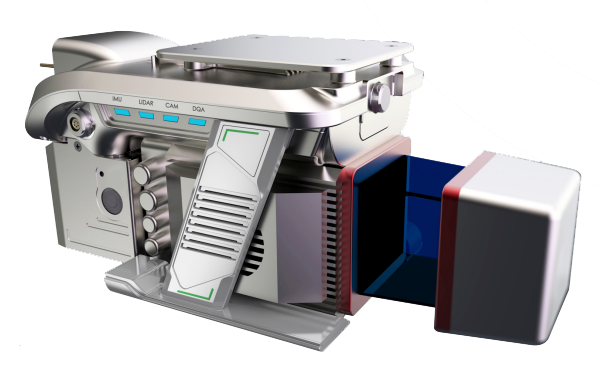
LiAir 250
LiAir 250 is GreenValley International's flagship UAV LiDAR system designed to meet survey-grade project requirements. It is equipped with a highly precise navigation system, and can generate point cloud data with an absolute vertical accuracy of 3 cm. Together with its capability of a 250 m range measurement and recording up to 5 returns per pulse, LiAir 250 is an ideal choice for applications like mapping terrain features beneath forest canopy, extracting forest structure parameters from individual tree level to forest stand level, inspecting power line corridor, managing and inspecting asset, and so on. Moreover, LiAir 250 also provides an option to be equipped with a high-definition digital camera, which can be used to generate photogrammetry products as well as true color 3D point clouds.
Features
- Lightweight - LiAir 250 weighs only 3.78 kg which makes it light and compact
- High Accuracy - Configure ultra-high precision camera to lock the object accurately
- One Button Start - One button to start, energy saving and high efficiency, improve performance
Simple Operation
One-button process data collection, one-button take-off and landing automatically executes the route
Real-Time Monitoring
The operation process supports real-time measurement of ground object coordinates, distance and elevation, and supports the rapid response to emergency rescue
Real-Time Measurement
The operation process supports real-time measurement of ground object coordinates, distance and elevation, and supports the rapid response to emergency rescue
Specifications:
| Laser Sensor | Riegl miniVUX-1 UAV |
| Range Accuracy | ± 15mm |
| Scan Range | 0.3 ~ 250m @ Reflectance ≥ 60% |
| System Accuracy | ± 3cm |
| POS System Performance | Attitude: 0.006° (1σ) Azimuth: 0.019° (1σ) |
| Onboard Storage | 128GB |
| Ports Available | Ethernet |
| Weight | 3.78kg excl. battery & camera |
| Dimensions (Main Unit) | 1105mm * 145mm * 148mm |
| Max Flight Time | 21 min (M600 Pro) |
| Camera | Sony a6000 (optional) |
| Route Planning Software | LiPlan (proprietary) |
| Acquisition/PP POS Software | LiAcquire (proprietary) |
| Field of View | up to 360° |
| Scan Rate | 100,000 pts/s |