CHCNav CGO GNSS Post-Processing Software

CHCNav

Precio:
Precio de venta$0.00 USD

Gastos de envío calculados en la caja

Stock:
Agotado

Store Pickup: List of available stores available on the Checkout page.

Descripción

  • Flexible Deployment: Compatible with Windows 7/8/10 (32/64-bit)
  • Multi-Mode Processing: Supports static, fast static, PPK, and PPP algorithms for GNSS accuracy
  • UAV & Road Support: Handles UAV trajectories, GCPs, and road design-based stakeout projects
  • Wide Format Support: Import/export RINEX, SHP, DXF, KML, CSV, PDF, TXT, and more
  • Geodetic Tools: Includes coordinate converters, map compressors, antenna manager, and COGO tools
  • Real-Time Map Integration: Connects to OSM, Google, Bing, WMS, and WMTS for base map views
  • Data Quality Check: Automated quality control and report generation for stations, baselines, and loops
  • Massive Data Handling: Efficiently processes large GNSS survey datasets and UAV flight logs

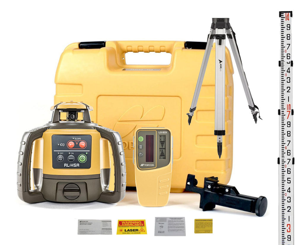
CGO2 is CHCNav’s advanced post-processing software for GNSS data, designed to bridge the gap between field data collection and accurate geodetic results. Built for surveyors, UAV operators, and construction professionals, CGO2 supports static, fast static, PPK, and PPP processing modes to deliver high-precision positioning in a wide range of applications.

With support for a wide variety of formats (RINEX, DXF, KML, CSV, and more), CGO2 enables seamless data editing, conversion, and export. It features a built-in suite of geodetic tools—including coordinate converters, road design editors, antenna managers, and map compressors—plus compatibility with online maps and CORS data download.

Its customizable interface and intuitive workflow make it accessible for both new and experienced users, whether you're processing UAV trajectography, GCPs, or road alignment surveys.

We will issue a refund in the original form of payment for merchandise that is unused & in original packaging within 14 days of purchase. Any defective merchandise can be exchanged within 30 days of purchase.

Exclusions: 

  • Special Order items include Software, GPS, Total Stations, Utility Locators, or Leica Geosystems products. 

  • We do not accept returns for replacement parts for any reason other than an error on our part.

  • Once an order has shipped, it cannot be cancelled. You may refuse the order upon delivery, in which case the standard return policy for the item will apply, and we will deduct the return shipping costs from your refund credit.

All merchandise returned after 14 days of purchase will have a 20% restocking fee & refund will only be available as store credit. 

The customer is responsible for return
shipping of any returned products, some exclusions may apply.

We do not accept returns or cancellations for special ordered items.

Special Order items include GPS, Total Stations, Utility Locators, or Leica Geosystems products. 

  • Every product comes with Benchmark's lifetime support. If your confused on something, we have experts on staff ready to help with post-sale support. 
  • Certified Repair Center with quick turnaround on warranty repairs.
  • We ship from 6 different locations to ensure quick delivery
  • Pickup at any of our local stores
  • Available to answer questions or take orders by phone at 866-342-7665 (8am-5pm, M-F)

Recently viewed